Albera mountains, on the traces of the Neolithic age
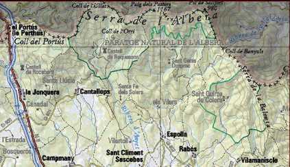
In the summer there are times when it seems that there are too many people at the coast around the Cap de Creus. But, only few kilometres away, in the Albera Mountains, one is amazed by the absence of the crush of tourists and the hectic atmosphere. This grandiose protected area starts at the Spanish French border, leading since 1659 along the mountain combs of the Pyrenees, and reaches approximately to an imaginary line between the villages of Capmany, Espolla and Vilamaniscle.

The Albera Mountains are not particular high and were therefore in earlier times the simplest connection between the Iberian Peninsula and the rest of Europe. During centuries, particularly during the Middle Ages, the Albera Mountains were quite inhabited. And in no other part of Catalonia can one find such a large number of megalithic structures (Menhirs and Dolmen) as within these low mountains with their gentle silhouette. The megalithic structures prove that the area was populated during the Neolithic age between 3500 and 1800 before Christ. There are about twenty sites of megalithic origin. Similar dolmen and menhirs can also be found in the deep south of Spain. How did these ancient people, so far from each other, both build similar structures?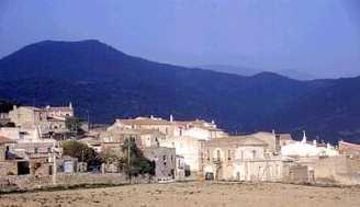
Also, within this area are Romanic churches, medieval castles. We recently visited the castle of Requesens. Plan on five hours for the trip. Drive in the direction La Jonquera and leave the road, shortly before the border toward Cantallops (wolf singing). The road leads us uphill through groves of olive trees. After we pass the pretty village Cantallops, the adventure on washed sand roads begins. Jeeps are particularly well suited for these roads. Anyone possessing a sporty vehicle with low-lying spoilers should find another automobile. After numerous curves we reach the top and dip into the green forest with its beeches, oaks and chestnut trees and we are now in the nature park of the Albera Mountains,an area, which remained exempted from civilization or industry.
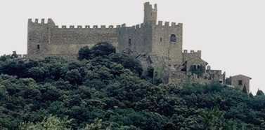
The castle Requesens is a strong fortress on the summit of a mountain in the midst of natural forest, in the midst of some enormous Lebanese cedars, which were planted long ago by the masters of the castle. One can get quite close to the castle by car, and the last 500 meters is a very pleasant walk. Travelling in the forest one should never assume that there would not be a surprise or two. Maybe a couple of wild pigs will cross your trail or you’ll spot a wild cow of the Albera Mountains. These cows, at 1.10 to 1.25 meters high, live at total liberty and are of tremendous interest to researchers. Attention, their horns are very sharply pointed.
At the last curve before the castle is an abandoned farm, which is also populated by these cows. The sound of their bells is to be heard throughout the whole forest. The castle was restored by the noble family Rocaberti at the end of the 19th Century. The castle has been uninhabited for decades and radiates a melancholic feeling. There is an information brochure and a map, which indicates another way back over Sant Climent de Sescebes, a somewhat better piste.
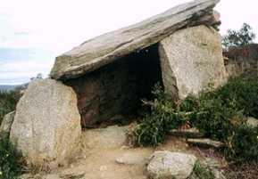 Half way, on a plateau with wonderful views of the Pic Neulos, the bay of Roses, the Pic d’Esquers up to the Serra del Puig, we find the menhir “Vilatoli “. Why did our ancestors construct and erect these blocks of stone, weighing many tons? We will probably never find the exact answer. Perhaps they just wanted to communicate to us that they existed? But the places, at which these buildings of stones are located, seem carefully selected. Both the Dolmen, simplest form of the stone graves, (the term originates from the Breton and means stone table) or the menhirs (megalithic stone) of religious origin are located at dominant or strategically favourable places. Not only the Vilatoli -Menhir on the right of the road, but also the Murtra -Menhir, hardly a kilometre further on the left of the road.
As the day ends one can usually see a shepherd with his enormous herd of sheep and his two dogs returning at home. Just like when the dolmens and menhir were new. We reach the civilization again with Sant Climent de Sescebes.
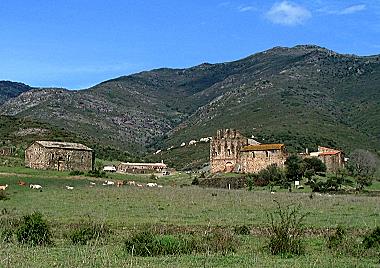
Another, likewise very interesting route leads from Vilamaniscle to the Benedictine monastery Sant Quirze de Colera and the Romanic church Santa Maria de Colera, which is nearly in its original state . 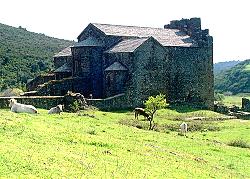 The remains of the monastery include a wonderful Basilica, the bell tower and the attachment walls. The buildings are within an elongated valley at the foot of the mountains “Pic de la Calma,” “Pic Jorda,” “Col de Banyuls” and “Col de Teixo.” On a slope under the monastery, a source of the best fresh drinking water flows into an old basin. The monks used this water, in order to irrigate their gardens and seed cultures.
On the way back to Vilamaniscle, about half way, close to the road is the menhir “Mas de Roquer,” also merits a stop.
These two ways are only a small part of the trips one can undertake into the Albera Mountains. In Espolla, the information office has maps and brochures on this protected area. It is always worthwhile to stop at the local information office to get the latest and most detailed information of an area or village. Also, remember to carry water, and some food, too, if you go on a discovery journey. An excellent map of this area is “Alt Empordà 2” with a very detailed scale of 1:50.000.
[cetsEmbedGmap src=https://maps.google.es/maps?q=Sierra+de+la+Albera,+Mass%C3%ADs+de+l%27Albera,+66740+Laroque-des-Alb%C3%A8res,+Francia&ie=UTF8&ll=42.424217,3.061752&spn=0.23417,0.528374&hnear=Sierra+de+la+Albera&t=h&z=12 width=350 height=425 marginwidth=0 marginheight=0 frameborder=0 scrolling=no]